TransPhotoГородской электротранспорт

Комментарии к фотографиям из города Амстердам

Фильтр


Отобразить все комментарии

««123456 ··· »»
Ссылка
Makach · Москва · 05.04.2022 18:01 MSK
Фото: 2
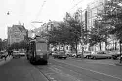
Чем то на Оку похож
0
+0 / –0
Ссылка
Aleksi · Санкт-Петербург · 20.02.2022 19:20 MSK
Фото: 475 · Локальный редактор — Финляндия
Priceless picture! Thanks for sharing!
+2
+2 / –0
Ссылка
focus1965 · Антверпен · 14.02.2022 22:33 MSK
Фото: 7618 · Общий редактор / Локальный редактор — Бельгия, Великобритания, Франция / Перевод сайта (EN/FR)
This is a former railway line, which is no longer necessary for normal operation. However, the line still retains its official status as a railway line, which has many legal implications.

https://transphoto.org/photo/1508022/

To put it very simply: the official tram company cannot impose standards on the museum tram, as they run at very low speeds on an old railway line, like local trains in the 1950s.
Of course, this does not apply once the trams enter the G.V.B. tram network.
On this line, the museum tram can ride as much as they want and this according to the standards of local railway lines.
0
+0 / –0
Ссылка
panStomil · Калининград · 14.02.2022 00:11 MSK
Фото: 23
А линия по которой ходит музейный трамвай 30 как использовалась ранее? Был какой-то маршрут или специально для музея построили?
0
+0 / –0
Ссылка
focus1965 · Антверпен · 13.02.2022 00:22 MSK
Фото: 7618 · Общий редактор / Локальный редактор — Бельгия, Великобритания, Франция / Перевод сайта (EN/FR)
The capacity of the metro alone is far from sufficient for the line to Amstelveen. This has everything to do with the Central Station terminus.

I have only used the old route 51 once. The Central Station terminus is small in every respect and is used by 3 lines, which not only have to share the 2 existing platforms, but also have to return there.

https://www.gleisplanweb.eu/Maps/Amsterdam2.pdf

An increase in frequency or longer trains is therefore out of the question.

The mixed operation (metro and tram) also had disadvantages: for the passengers who sometimes had to walk from one platform to the other and, of course, irregular operation.

Of course, they could have organised a metro route via the new metro line, but the tram passengers were against that and apparently they can shout louder than the metro passengers...
+1
+1 / –0
Ссылка
АК (Александр) · Москва · 12.02.2022 23:48 MSK
Фото: 2956 · Локальный редактор — Рубцовск
В 2010 году на этом месте уже соорудили еще одну эстакаду, прямо на месте бывших путей 5 трамвая.
Вообще, со стороны впечатление, что транспортные условия ухудшились. Раньше была очень короткая пересадка с 5 трамвая на метро, теперь идти целый квартал.
В целом, для жителей пригорода Amstel раньше был прямой маршрут в центр, 51, теперь нужно пересаживаться. Да и пересадка не очень то близкая.
Я так и не понял, в чем смысл менять 51 маршрут метро на трамвай
+1
+1 / –0
Ссылка
focus1965 · Антверпен · 12.02.2022 23:27 MSK
Фото: 7618 · Общий редактор / Локальный редактор — Бельгия, Великобритания, Франция / Перевод сайта (EN/FR)
That is indeed what it was. I am more or less familiar with what happens in Amsterdam, but this was quite difficult to reconstruct even for me, also because there was an intermediate version (2008-2019) that I never visited. So that means I could locate the photo, but it did not match your 2013 map. So it has been clarified: the map is correct (not that I doubted it!) and the photo is of an older date.
+1
+1 / –0
Ссылка
АК (Александр) · Москва · 12.02.2022 23:16 MSK
Фото: 2956 · Локальный редактор — Рубцовск
Огромное вам спасибо!" Крайне интересная схема!
Нашел это место на панорамах Google за 2008 год.
https://www.google.be/maps/@52.3392023,4...6?hl=nl
Старше панорам нет, к сожалению
+1
+1 / –0
Ссылка
focus1965 · Антверпен · 12.02.2022 22:57 MSK
Фото: 7618 · Общий редактор / Локальный редактор — Бельгия, Великобритания, Франция / Перевод сайта (EN/FR)
https://www.gleisplanweb.eu/netze/Amsterdam/Zuid.png

map 1: till 2008.
map 2: between 2008 and 2019.

The photo from Urban Transport Magazine was made before 2009.
+1
+1 / –0
Ссылка
АК (Александр) · Москва · 12.02.2022 22:41 MSK
Фото: 2956 · Локальный редактор — Рубцовск
Спасибо за ответ. То есть раньше 5 трамвай ходил с южной стороны от Станции метро?
+1
+1 / –0
Ссылка
focus1965 · Антверпен · 12.02.2022 19:33 MSK
Фото: 7618 · Общий редактор / Локальный редактор — Бельгия, Великобритания, Франция / Перевод сайта (EN/FR)
The connection doesn't exist anymore, but it was here (or this one):

https://goo.gl/maps/gKnerwNHJEcDB1EQ8

In 2021 you couldn't find anything more:

https://goo.gl/maps/oEiEjH8aTpnMRTjd6
0
+0 / –0
Ссылка
АК (Александр) · Москва · 12.02.2022 10:31 MSK
Фото: 2956 · Локальный редактор — Рубцовск
Вопрос к знающим Амстердам.
https://www.urban-transport-magazine.com...elveen/
Второй снимок сверху, где трамвай 5 едет внизу, а поезд 51 вверху по эстакаде. Вот где это? Голову ломаю, но не могу понять?
0
+0 / –0
Ссылка
АК (Александр) · Москва · 12.02.2022 09:22 MSK
Фото: 2956 · Локальный редактор — Рубцовск
Забавно, что у трамвая теперь остановок меньше, чем было у метро. Из 11 остановок на "сольном" участке 51 у 25 трамвая осталось 7. Закрыли 4 промежуточные станции
0
+0 / –0
Ссылка
focus1965 · Антверпен · 12.02.2022 00:14 MSK
Фото: 7618 · Общий редактор / Локальный редактор — Бельгия, Великобритания, Франция / Перевод сайта (EN/FR)
The importation of American cars (but also many other products, think of Coca-Cola) was a direct consequence of WWII. The Americans liberated this region from the Nazis. In gratitude, little or no duties or taxes were imposed on the import of American products afterwards.

The sign is a road sign. For a long time (since 1908) there has been a very systematic effort to standardise road signs. 4 years after this photo was taken, the Vienna Convention on Road Signs and Signals was held.

https://en.wikipedia.org/wiki/Vienna_Con...n%20use

So this kind of sign systematically disappeared after 1968 (there must have been a transition period).
0
+0 / –0
Ссылка
panStomil · Калининград · 11.02.2022 01:24 MSK
Фото: 23
> Цитата (Alstom Citadis, 09.02.2022):
> > Интересно, как технически/геометрически возможно движение поездов метро и трамваев по одной инфраструктуре?
>
Выглядело это так: по разделительной полосе проложена линия,по которой ездят и трамваи и метро. Останавливаются на светофорах, перекрёстки проезжают. Все остановки двойные-сначала идёт низкий перрон для трамваев, потом высокий для метро.
Вообще метро на старых линиях оно такое больше как электричка. От вокзала до какой-то жд станции едет как метро, потом выезжает на поверхность и едет вдоль жд по своим отдельным путям. И вот один из маршрутов потом съезжал на трамвайную линию.
В Амстердаме городской транспорт и железная дорога как-то не интегрированы. В той же Германии или Польше на железной дороге могли бы понаделать кучу остановок в городе и сделать так чтобы в пределах города билеты на городской транспорт действовали в электричках,а в Амстердаме вместо этого вдоль существующей жд проложили ещё пути и запустили метро
0
+0 / –0
Ссылка
panStomil · Калининград · 11.02.2022 01:17 MSK
Фото: 23
Смотрю и в Европе тогда в автомобилестроении был в моде "американский" стиль

А что за дорожные знаки на столбе? Для трамваев?
0
+0 / –0
Ссылка
panStomil · Калининград · 11.02.2022 00:48 MSK
Фото: 23
Цитата (АК (Александр), 08.02.2022):
> - на 26 построено новое кольцо с северной стороны центрального вокзала. На панорамах от 20 года там виден трамвай. Сейчас, судя по официальному сайту, трамваи 26 маршрута снова ходят до старого кольца. По какой причине, не знаю.

Вроде как новое кольцо построена на всякий случай. Потому что при проведении некоторых массовых мероприятий (например,марафон) приходилось перекрывать движение и трамвай 26 не мог подъехать к вокзалу. Для таких случаев и сделали кольцо.
А зачем перед въездом в тоннель на маршруте 26 сделано какое-то служебное путевое развитие?
0
+0 / –0
Ссылка
Kestutis · 09.02.2022 10:59 MSK
Нет фотографий
Citata (Alstom Citadis, 09.02.2022):
> Интересно, как технически/геометрически возможно движение поездов метро и трамваев по одной инфраструктуре?

можете покататься в youtube по этой трассе на метро и сами посмотреть интересно выглядели двойные остановки с высокой платформой для метро и низкой для трамвая.
0
+0 / –0
Ссылка
Alstom Citadis · Харьков · 09.02.2022 02:17 MSK
Нет фотографий
Цитата (АК (Александр), 07.02.2022):
> линия метро заменена на трамвай

Надо же, чё в природе бывает... Интересно, как технически/геометрически возможно движение поездов метро и трамваев по одной инфраструктуре?
Вообще поразительная сеть: при такой сумасшедшей разветвлённости путей всего лишь 15 маршрутов и всего 223 вагона
0
+0 / –0
Ссылка
focus1965 · Антверпен · 08.02.2022 23:35 MSK
Фото: 7618 · Общий редактор / Локальный редактор — Бельгия, Великобритания, Франция / Перевод сайта (EN/FR)
I translate the very interesting text from AK for the international (and Dutch) users. His comments are extremely valuable.

I Updated the layout of one of Europe's most tram-friendly cities after 9 years.
In that time, there have been big changes to the network.
- new metro line 52 opened
- Underground line 51 on the southern section is replaced by tram line 25. Some stations closed, most of the joint section with tram 5 rebuilt, island platforms built. I have tried to map the island platforms, redrawn the whole southern piece.
- The 5 tram has been let down instead of the Central station along the city half-ring of the former triplet. Apparently it was done because a piece of line and ring was cut off at Marnixplein, a temporary exit was made, and two-way coaches were needed, which only exist on route 5 of the Central route.
- Route 10 has been cancelled. It's covered by the modified 1, 3 and 7.
- Route 14 is directed to central station, instead of duplicating the westbound section of 7
- 12 also to central now, instead of Sloterdijk, instead of the changed 1 and 5.
Amstel terminus has been rebuilt, with a building built in place of the ring. I've mapped both the old and new version.
- The 1 on the small half-ring, instead of the centre, is the most frequent route at the moment.
- Instead of the 9, there's now a 19 which doesn't go to the centre, but to Sloterdijk. The Diemen terminus has been redesigned, a building has been built there, the direction of travel has been changed, and the ring has been redrawn.
- 16 cancelled, 24 now goes via De Pijp, the line on Krusemanstraat is now virtually without route traffic. Only 2 runs there in May. What this has to do with, I don't know.
- The old 25 line with the ring around President Kennedy Street has been dismantled, with only a piece left to the depot.
- on 26, a new ring has been built on the north side of Grand Central Station. Panoramas from '20 show a tram there. Now, according to the official website, route 26 goes back to the old loop. For what reason, I do not know.
- All routes are being worked out for new names. A lot of stops are closed. Apparently, the routes were sped up.
- there's a new cardboard layout, from the 22nd. Replacing it in the case of Amsterdam was quite a hassle, many streets were redrawn by users and didn't match the tram lines. Also, the scheme has broken the absolute record for the size of an Adobe Illustrator vector file, over 106 megabytes :)
- service lines are now orange

Remark to other comments:

The museum tramway has a special status. The number 30 is 100 % correct, because there is an official link with the tram company. However, the line itself is still officially a railway line, where a totally different set of regulations applies, which is much more favorable to the tram museum.
+1
+1 / –0
««123456 ··· »»